Scheduled Downtime
On Friday 21 April 2023 @ 5pm MT, this website will be down for maintenance and expected to return online the morning of 24 April 2023 at the latest

Regional MPAS initial / boundary condition issue

BAMS

New member
Dear,

I'm running regional MPAS v8.0.1 for a location in the Dutch north sea, using ERA5 and OSTIA data for IC&BC.
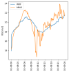
When analyzing the wind speed at ~25 m above surface and comparing them to WRF, I noticed huge fluctuations in the MPAS prediction (see figure ts.png).
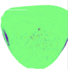
Digging deeper, I noticed a large vertical wind speed upon initialization at the edges of the domain (see figure t0.png), which seem to shed waves through the domain (see figure t60.png).

I assume this issue is related to what was shown in Figure 14 in Limited-Area Atmospheric Modeling Using an Unstructured Mesh; so I'm currently using the 60-3km variable resolution mesh, with a domain size large enough so that the outermost cells are indeed approximately 60km large.
Any suggestion on how to prevent this would be greatly appreciated.

I have attached my namelist files. If any more information is required, please let me know.
Thanks in advance
 

Attachments

  • t0.png
    t0.png
    30.3 KB · Views: 9
  • t60.png
    t60.png
    99.3 KB · Views: 8
  • ts.png
    ts.png
    33.2 KB · Views: 8
  • namelist.atmosphere.txt
    1.3 KB · Views: 2
  • namelist.init_atmosphere1.txt
    1.4 KB · Views: 3
  • namelist.init_atmosphere2.txt
    1.4 KB · Views: 2
  • namelist.init_atmosphere3.txt
    1.4 KB · Views: 3
In your namelist.init_atmopshere1.txt (the namelist for creating initial condition), you set

config_blend_bdy_terrain = false

Please change it to

config_blend_bdy_terrain = true,

Then rerun init_atmosphere_model.
 
Dear Ming Chen,

Unfortunately, this did not make a significant difference.
I have attached the updated figure and namelist files.

Any other suggestions?
Thanks!
 

Attachments

  • namelist.init_atmosphere3.txt
    1.4 KB · Views: 3
  • namelist.init_atmosphere2.txt
    1.4 KB · Views: 2
  • namelist.init_atmosphere1.txt
    1.4 KB · Views: 3
  • namelist.atmosphere.txt
    1.3 KB · Views: 2
  • t0.png
    t0.png
    29.1 KB · Views: 7
I will take a look at this case and get back to you later.

It may take some time and thank you for your patience.
 
Hi,
Would you please clarify how you interpolate MAPS and WRF data to ~25m above the ground? What is the resolution of your WRF run? I guess the results shown in ts.png is domain-averaged wind speed, please let me know if I am wrong.
When you calculate domain average wind speed of MPAS, did you exclude the outermost 2 layers? Values at these 2 layers are specified to large scale forcing data, and should be excluded from post process diagnostic calculation.
 
Dear Ming,

The results I showed before are from one cell in the center of the domain, both for MPAS and for WRF. It is therefore note the issue that the outermost 2 layers are included.
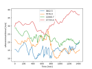
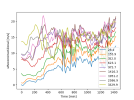
It is also not an interpolation issue. Below I extracted the 'uReconstructZonal' directly from the output file specified in my streams.atmosphere file, also for this point only. Resulting figures are attached, with the legend indicating the height above surface. You can see that these fluctuations persist in the full boundary layer (u_lower.png). Albeit with a smaller magnitude, also higher up in the atmosphere (u_upper.png) some fluctuations can be seen.

Thanks for taking the time to look at this!
 

Attachments

  • u_upper.png
    u_upper.png
    65.8 KB · Views: 7
  • u_lower.png
    u_lower.png
    124.1 KB · Views: 6
Hi,
Thank you for the detailed explanation. I am sorry that I don't have an immediate answer to the question why wind fluctuates so violently at individual cells. We have looked at domain-averaged wind speed and compared it with WRF simulation. It turned out that the two models can yield quite similar results.
 
Dear,

I'm running regional MPAS v8.0.1 for a location in the Dutch north sea, using ERA5 and OSTIA data for IC&BC.
When analyzing the wind speed at ~25 m above surface and comparing them to WRF, I noticed huge fluctuations in the MPAS prediction (see figure ts.png).
Digging deeper, I noticed a large vertical wind speed upon initialization at the edges of the domain (see figure t0.png), which seem to shed waves through the domain (see figure t60.png).

I assume this issue is related to what was shown in Figure 14 in Limited-Area Atmospheric Modeling Using an Unstructured Mesh; so I'm currently using the 60-3km variable resolution mesh, with a domain size large enough so that the outermost cells are indeed approximately 60km large.
Any suggestion on how to prevent this would be greatly appreciated.

I have attached my namelist files. If any more information is required, please let me know.
Thanks in advance
Dear @BAMS : as you were used ERA5 for IC and LBC, I would like asking about that.
Currently I have a problem to produce IC using ERA5, because I need to set config blend bdy terrain = true.
And that need SOILHGT variable that is not provided in ERA5 dataset.
I would like to askm how you produce the IC and LBC.

Thank you.

.
 
In ungrib SOILHGT is copied from SOILGEO, which is the geopotential height at the surface (Z at level 0). This is what I refer to you should download from copernicus under other > geopotential
 
Top