Hello,
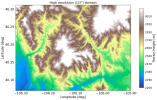
I downloaded USGS 1/3" topographic data for some simulations I am working on. I was able to stitch together multiple tiles into my own dataset according to WRF guidelines (i.e. the whole 0xxxx-0xxxx.0yyyy-0yyyy naming conventions), and can successfully run geogrid.exe and generate maps. However, at the boundary between tiles, I get this repeating effect, where it looks like the same data is contained in each tile. The repeating overlap is constrained to less than 0.01 degrees of longitude.
I would expect that this would be fixed by specifying the "tile_bdr" field in my data index files -- but nothing I have tried has worked. Any value that I put in there besides 0 spits out complete nonsense. I have tried checking my maps to see how many grid spacings away these similar elevations are, but could not find a simple solution.
Does anyone have any advice or suggestions for me? I used the "convert_geotiff" routine described here (How to convert data for Geogrid - openwfm) on each of my individual .tiff files, renamed the binary files to correspond to the correct locations in the combined grid set, and then wrote the index file attached below for the combined set of four tiles (2x2).
Thanks for any help yall can give!
Best,
Joey