blaylockbk
New member
Summary
After running init_atmosphere to generate a static.nc file for a 60 3-km mesh centered over Guam, there are no land points over Guam in the output; there are only water points where Guam should be.
Details
I have set up an MPAS experiment for a 60-3 km variable resolution mesh rotated over Guam.
This is my namelist.input for rotating the mesh
I ran init_atmosphere with the following namelist and streams
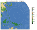
After generating a static file, I plotted the ivgtyp and overlayed the mesh refinement, to confirm things look as expected and that my mesh is rotated to the right location.

But, when I zoom into Guam, there are no land points where Guam should be. It's all water

I can also confirm that the raw MODIS 30s tile does have Guam in it (right). I even checked with the raw MODIS 15s data (left).

Below is the MPAS cell centers from my staic.nc file, overlaid the raw MODIS 30s tile. It seems to me that there are enough MPAS cells over Guam that there should have been some cells to represent Guam in MPAS.

Question:
Is there something with how init_atmosphere is working that would prevent it from interpolating the MODIS landuse for Guam? Are there any namelist options I could change to make sure Guam landuse is handled properly in the interpolation? (Maybe I need to check that the raw topographic data has Guam in it?)
After running init_atmosphere to generate a static.nc file for a 60 3-km mesh centered over Guam, there are no land points over Guam in the output; there are only water points where Guam should be.
Details
I have set up an MPAS experiment for a 60-3 km variable resolution mesh rotated over Guam.
This is my namelist.input for rotating the mesh
&input
config_original_latitude_degrees = 0
config_original_longitude_degrees = 0
config_new_latitude_degrees = 13.3824
config_new_longitude_degrees = 144.6973
config_birdseye_rotation_counter_clockwise_degrees = 0
/
I ran init_atmosphere with the following namelist and streams
&nhyd_model
config_init_case = 7
config_start_time = '2025-08-01_00:00:00'
config_stop_time = '2025-08-02_00:00:00'
config_theta_adv_order = 3
config_coef_3rd_order = 0.25
config_interface_projection = 'linear_interpolation'
/
&dimensions
config_nvertlevels = 55
config_nsoillevels = 4
config_nfglevels = 38
config_nfgsoillevels = 4
config_gocartlevels = 30
/
&data_sources
config_geog_data_path = '/path/to/my/mpas_static'
config_met_prefix = 'CFSR'
config_sfc_prefix = 'SST'
config_fg_interval = 86400
config_landuse_data = 'MODIFIED_IGBP_MODIS_NOAH'
config_soilcat_data = 'STATSGO'
config_topo_data = 'GMTED2010'
config_vegfrac_data = 'MODIS'
config_albedo_data = 'MODIS'
config_maxsnowalbedo_data = 'MODIS'
config_supersample_factor = 3
config_lu_supersample_factor = 1
config_30s_supersample_factor = 1
config_use_spechumd = false
/
&vertical_grid
config_ztop = 30000.0
config_nsmterrain = 1
config_smooth_surfaces = true
config_dzmin = 0.3
config_nsm = 30
config_tc_vertical_grid = true
config_blend_bdy_terrain = false
/
&interpolation_control
config_extrap_airtemp = 'lapse-rate'
/
&preproc_stages
config_static_interp = true
config_native_gwd_static = true
config_native_gwd_gsl_static = false
config_vertical_grid = false
config_met_interp = false
config_input_sst = false
config_frac_seaice = false
/
&io
config_pio_num_iotasks = 0
config_pio_stride = 1
/
&decomposition
config_block_decomp_file_prefix = 'x20.835586.graph.info.part.'
/
<streams>
<immutable_stream name="input"
type="input"
filename_template="guam.x20.835586.grid.nc"
input_interval="initial_only" />
<immutable_stream name="output"
type="output"
filename_template="guam.x20.835586.static.nc"
packages="initial_conds"
output_interval="initial_only" />
<immutable_stream name="ugwp_oro_data"
type="output"
filename_template="x1.40962.ugwp_oro_data.nc"
packages="gwd_gsl_stage_out"
output_interval="initial_only" />
<immutable_stream name="surface"
type="output"
filename_template="x1.40962.sfc_update.nc"
filename_interval="none"
packages="sfc_update"
output_interval="86400" />
<immutable_stream name="lbc"
type="output"
filename_template="lbc.$Y-$M-$D_$h.$m.$s.nc"
filename_interval="output_interval"
packages="lbcs"
output_interval="3:00:00" />
</streams>
After generating a static file, I plotted the ivgtyp and overlayed the mesh refinement, to confirm things look as expected and that my mesh is rotated to the right location.
But, when I zoom into Guam, there are no land points where Guam should be. It's all water
I can also confirm that the raw MODIS 30s tile does have Guam in it (right). I even checked with the raw MODIS 15s data (left).
Below is the MPAS cell centers from my staic.nc file, overlaid the raw MODIS 30s tile. It seems to me that there are enough MPAS cells over Guam that there should have been some cells to represent Guam in MPAS.
Question:
Is there something with how init_atmosphere is working that would prevent it from interpolating the MODIS landuse for Guam? Are there any namelist options I could change to make sure Guam landuse is handled properly in the interpolation? (Maybe I need to check that the raw topographic data has Guam in it?)