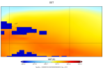
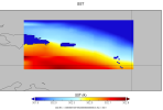
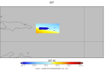
Hello there, I hope you're all having a good holiday season. I am working on a Puerto Rico model focused on the Saharan Air Layer using future CMIP5 RCP 8.5 data (link below):
CISL RDA: NCAR CESM Global Bias-Corrected CMIP5 Output to Support WRF/MPAS Research
This data-set is in the form of interim files so I downloaded them and ran metgrid as per usual (after altering the METGRID.TBL to change the SST portion to what was recommended by the NCAR/UCAR folks ( link here )).

Metgrid runs perfectly fine, but when I look at the SSTs I get this bizarrely distorted box around Puerto Rico.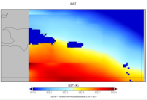
My initial thought was that this was a result of some problem with either the LANDMASK or the LANDSEA; however, after looking at both of these for this domain neither seem to match up with the SST box outline.
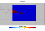
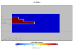
As you can probably see, the outlines are too close around Puerto Rico and the Dominican Republic to match with the box in the SSTs. I thought it might have been the CMIP-recommended METGRID.TBL SST section, but even when running with the default values for the SST in METGRID.TBL I see the same box around the island. I'm now a little stumped as to what could influence the SSTs like that so any information on it would be greatly appreciated. Happy holidays! P.S. I've also included my namelist.wps.
CISL RDA: NCAR CESM Global Bias-Corrected CMIP5 Output to Support WRF/MPAS Research
This data-set is in the form of interim files so I downloaded them and ran metgrid as per usual (after altering the METGRID.TBL to change the SST portion to what was recommended by the NCAR/UCAR folks ( link here )).

Metgrid runs perfectly fine, but when I look at the SSTs I get this bizarrely distorted box around Puerto Rico.

My initial thought was that this was a result of some problem with either the LANDMASK or the LANDSEA; however, after looking at both of these for this domain neither seem to match up with the SST box outline.


As you can probably see, the outlines are too close around Puerto Rico and the Dominican Republic to match with the box in the SSTs. I thought it might have been the CMIP-recommended METGRID.TBL SST section, but even when running with the default values for the SST in METGRID.TBL I see the same box around the island. I'm now a little stumped as to what could influence the SSTs like that so any information on it would be greatly appreciated. Happy holidays! P.S. I've also included my namelist.wps.

