Dear all,
I'm writing a follow-up on this topic because the issue still persists in the latest model version, WRFV4.7.0.
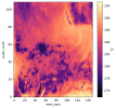
The problem remains the formation of persistent, steady cold patches that appear near the surface in association with extensive cloud cover. These patches emerge after a few days of simulation.
I understand that WRF is primarily designed for short-term numerical weather prediction. However, this is not simply a case of the model developing biases over long-term integration. Rather, the phenomenon appears completely unphysical and may indicate a potential code error. Given the widespread use of WRF as a regional climate model, I believe this issue warrants thorough investigation.
To support this, I’ve uploaded output from the first few days of my simulation. In the hourly_output_d02_* files, the variables T2 and TSK clearly show unphysical values (e.g., over the western parts of the domain) as early as the second day of integration.
I’ve also included the namelist.input and met_em* files to facilitate reproducibility. The initial and boundary conditions are from ERA5.
Please follow this
link to access the files.
I hope we can eventually find a solution to this.
Best regards,
Akos