Hello,
In the past couple weeks, i have been trying to use the CLC data with the WPS instead of the default MODIS data. After reviewing some thread here regarding the subjects, those are the steps i have taken:
1. I downloaded the CLC data from their website.
2. I reclassified the data based on a table i found in this paper : https://www.researchgate.net/figure...-from-the-CLC-to-modified-IGBP_tbl2_342176597
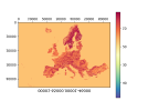
3. I used gdal_translate to convert my tiff fie to binary. i plotted the binary file to validate that the file was converted successfully (i will include the plot as attachment)
4. i renames the binary based on the values i got from the gdal_translate. The final name ended up like this : 00001-65000.00001-46000
5. i created an index file which i will also be including (i suspect here is my problem)
5. i edited the GEOGRID.TBL to read from the binary file and the index file i created instead from the default data.:
Finally i ran ./geogrid.exe and ./metgrid.exe and i used ncview to view the generated ncfiles.
My problem is that ncview isnt showing me any information when i choose LANDUSEF.
I am pretty sure that the values i am setting in my index file are somehow incorrect, but even after i read the documentation of the index file which i found here: Chapter 3: WRF Standard Initialization , i still cant understand what the values are in my case.
i will be attaching namelist.wps, GEOGRID.TBL and the index file as txt files, but on the server they are not txt files.
I would appreciate every single help.
Thank you
In the past couple weeks, i have been trying to use the CLC data with the WPS instead of the default MODIS data. After reviewing some thread here regarding the subjects, those are the steps i have taken:
1. I downloaded the CLC data from their website.
2. I reclassified the data based on a table i found in this paper : https://www.researchgate.net/figure...-from-the-CLC-to-modified-IGBP_tbl2_342176597
3. I used gdal_translate to convert my tiff fie to binary. i plotted the binary file to validate that the file was converted successfully (i will include the plot as attachment)
4. i renames the binary based on the values i got from the gdal_translate. The final name ended up like this : 00001-65000.00001-46000
5. i created an index file which i will also be including (i suspect here is my problem)
5. i edited the GEOGRID.TBL to read from the binary file and the index file i created instead from the default data.:
6. I edited the namelist.wps:landmask_water = corine_30s:17
interp_option = corine_30s:nearest_neighbor
rel_path = corine_30s:clc_data/
geog_data_res = 'corine_30s','corine_30s','corine_30s',
Finally i ran ./geogrid.exe and ./metgrid.exe and i used ncview to view the generated ncfiles.
My problem is that ncview isnt showing me any information when i choose LANDUSEF.
I am pretty sure that the values i am setting in my index file are somehow incorrect, but even after i read the documentation of the index file which i found here: Chapter 3: WRF Standard Initialization , i still cant understand what the values are in my case.
i will be attaching namelist.wps, GEOGRID.TBL and the index file as txt files, but on the server they are not txt files.
I would appreciate every single help.
Thank you