kaitlinkitch
New member
Hello everyone,
I recently ran a control simulation of Hurricane Sandy using WRF on Derecho. For my simulations, we will be perturbing the SSTs in the North Atlantic, so I am inputting my own SST fields into WRF. To do this, I am running WPS, editing the SST in the Metgrid files, and then using them to run WRF as normal. I successfully ran the model, but I have been looking at the SST fields in the wrfout files to verify WRF is "seeing" the correct SSTs. Upon my analysis, I found some subtle anomalies over the Great Lakes region, otherwise the SST fields are identical. I found that these differences are generated somewhere between the SST field in the wrflowinp files generated by real.exe and the SST field in the wrfout files. I attached a figure here showing the differences. The magnitudes seem to be on the order of 0.01-0.1K. I was wondering if anyone has experienced similar issues or if WRF struggles to resolve the Great Lakes?
This figure shows the differences between the SST in the wrfout file at one timestep compared to the SST in the wrflowinp file. This is on my innermost domain of a 3 nest domain simulation. It is run at 3km resolution. I found that when the SSTs across the simulation are held constant, the anomalies are no longer present. They only exist over the Great Lakes when the SSTs are allowed to vary.
Any insight is greatly appreciated!
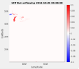