WRF v4.1.1 PX LSM T2 error around the coastline

Heo

New member
Dear all


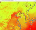
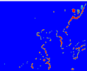
I am using the PX LSM for WRF modeling.
When using other LSMs, this issue does not occur, but with PX LSM, CLDFRA is simulated to be very high along the coastline, and T2 is modeled to be very low.
I am currently in a situation where I must use PX LSM.
If you know any solutions to this problem, I would greatly appreciate your guidance.

Heo
 

Attachments

  • T2.png
    T2.png
    104 KB · Views: 0
  • CLDFRA.png
    CLDFRA.png
    7.2 KB · Views: 0
  • namelist.input.txt
    namelist.input.txt
    7.9 KB · Views: 1
Heo,

if you run with PX surface scheme, then num_soil_layers should be 2 instead of 4. Can you change your namelist.input and rerun this case?

However, I am not sure whether this could be the reason for the unrealistic T2 and CLDFRA along the coast.

This issue looks more like a problem of landuse type or sst_update, --- but I am perplexed that other land models don't have this problem.

What data did you use to drive this case?
 
I have resolved the issue of abnormal T2 simulation by modifying the geogrid land use data.
However, could you please explain why it is necessary to set the soil layer to 2?
 
Please clarify how you modify geogrid land use data to solve the coastline issue. Thanks in advance.

For the soil layers, different land surface schemes have different soil levels. This is related to the designation of specific scheme.

PX LSM only handles soil physics in 2 soil layers, while Noah uses 4 soil layers.
 
Back
Top