Hi
I tried to insert srtm data 3s in geogrid. It works fine.
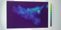
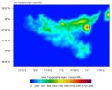
But i didn t understand why if i plot HGT_M from geogrid nc file i see flat map and i didn t see any big difference respect to the default
Attached a picture . Could be the way to plot HGT_M? Have you specifica script?
I tried to insert srtm data 3s in geogrid. It works fine.
But i didn t understand why if i plot HGT_M from geogrid nc file i see flat map and i didn t see any big difference respect to the default
Attached a picture . Could be the way to plot HGT_M? Have you specifica script?


