Hello all,
I am currently running WRF simulations with the goal of resolving rather short wavelength (high-frequency) wave motions in the lee of a mountain range (wavelength of several km and period of 1-10 min); in the past these motions were attributed to KH instability between the shooting downslope windstorm flow and the stagnation zone above.
I am currently running a 9-3-1-0.333 km 4-domain nested (feedback on) simulation and have at last managed to get time series and spectra very similar to the observed ones, if of a smaller amplitude. However, I was only able to get these results if gwd_opt=1 was ON on ALL the domains. I have tried gwd_opt=1 on only 1, 2 and 3 domains and none did it for me, only when it was on the finest domain as well.
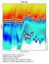
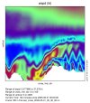
Now, my question is the following - the WRF guide says that gwd_opt is recommended ON for all domains, but as I understand it, gwd_opt is intended to parametrize subgrid orography wave drag effects (and blocking) ; surely on a 1 km and 333 m domain these effects should be resolved; in that case am I "double-counting" gravity wave drag? Also, the gwd_opt input data is coarse, 10m in resolution, which sometimes (above the ground) results in unsightly squares (picture included, left - terrain, right - U at level 12, around 800 m a.g.l. with dzbot=20 and dzstretch_s=1.05). Vertical level resolution has no effect on this, as 60 and 80 levels provided the same results.
What are your opinions? Should gwd_opt be on for ALL domains (no matter how small they are)? I know the guide says the gwd_opt=3 is recommended for < 1km resolutions. I have not found a study which argues either way. On the other hand, added wave drag should enhance low-level instabilities since the drag enhances wind shear, and to keep the simulation from exploding in complex terrain I had to add vertical damping. Perhaps these two effects cancel each other out partially. The added wave instabilities are not perpendicular to the wave sides so I don't think they are caused by the potential discontinuities at the edges of the squares.
There are other parameters which may impact the simulation; namely the terrain resolution on domains 1, 2, and 3 is the 30-arcsecond default dataset, while on domain 4 it is the ASTER 1-arcsecond dataset. I will run a simulation with gwd_opt=1 on all domains and no ASTER terrain and report back. I will also try the gwd_opt=3 option as well. Don't getme wrong, the result is exciting since it does reproduce the measured spectra well at the required frequencies, I just wonder if the result could be an artefact of using unsuitable parametrizations. Thank you very much in advance,
Petar Golem, MSc


