Hello,
I am trying to apply a custom landuse dataset (EGIS Landuse for Korea) to WPS geogrid.
The dataset was converted into BIL tiles (200×200 pixels each, 30 arc-sec resolution), and I created an index file as follows:
I also updated GEOGRID.TBL with:
But when I run geogrid.exe, it fails:


My questions:
Thanks in advance!
I am trying to apply a custom landuse dataset (EGIS Landuse for Korea) to WPS geogrid.
The dataset was converted into BIL tiles (200×200 pixels each, 30 arc-sec resolution), and I created an index file as follows:
INI:
type=categorical
category_min=1
category_max=21
projection=regular_ll
dx=0.00083333
dy=0.00083333
known_x=1
known_y=6201
known_lat=38.375263165
known_lon=125.074916365
wordsize=1
row_order=top_bottom
tile_x=200
tile_y=200
tile_z=1
missing_value=0
units="category"
description="EGIS Landuse KOREA"
mminlu="MODIFIED_IGBP_MODIS_NOAH"
iswater=17
islake=21
isice=15
isurban=13
JavaScript:
===============================
name=LANDUSEF
        priority = 2
        dest_type = categorical
        z_dim_name = land_cat
        landmask_water =  egis_landuse_korea:17,21      # Calculate a landmask from this field
        interp_option =  egis_landuse_korea:nearest_neighbor
        rel_path =   egis_landuse_korea:egis_landuse_korea/
===============================
name=LANDUSEF
        priority=1
        dest_type=categorical
        z_dim_name=land_cat
        dominant = LU_INDEX
But when I run geogrid.exe, it fails:
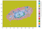
- success image example

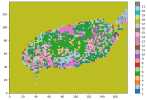
- fail image

My questions:
- Is my index file configuration correct for multiple 200×200 tiles?
- Do all tiles need exactly the same extent, or only the same dx/dy and snapping?
- Are there common pitfalls when using custom categorical datasets for landuse (e.g., file naming, projection)?
Thanks in advance!
