Scheduled Downtime
On Friday 21 April 2023 @ 5pm MT, this website will be down for maintenance and expected to return online the morning of 24 April 2023 at the latest

Problem applying custom EGIS landuse dataset in WPS geogrid

aba0327

New member
Hello,


I am trying to apply a custom landuse dataset (EGIS Landuse for Korea) to WPS geogrid.
The dataset was converted into BIL tiles (200×200 pixels each, 30 arc-sec resolution), and I created an index file as follows:
INI:
type=categorical
category_min=1
category_max=21
projection=regular_ll
dx=0.00083333
dy=0.00083333
known_x=1
known_y=6201
known_lat=38.375263165
known_lon=125.074916365
wordsize=1
row_order=top_bottom
tile_x=200
tile_y=200
tile_z=1
missing_value=0
units="category"
description="EGIS Landuse KOREA"
mminlu="MODIFIED_IGBP_MODIS_NOAH"
iswater=17
islake=21
isice=15
isurban=13
I also updated GEOGRID.TBL with:
JavaScript:
===============================
name=LANDUSEF
        priority = 2
        dest_type = categorical
        z_dim_name = land_cat
        landmask_water =  egis_landuse_korea:17,21      # Calculate a landmask from this field
        interp_option =  egis_landuse_korea:nearest_neighbor
        rel_path =   egis_landuse_korea:egis_landuse_korea/
===============================
name=LANDUSEF
        priority=1
        dest_type=categorical
        z_dim_name=land_cat
        dominant = LU_INDEX

But when I run geogrid.exe, it fails:
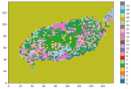
  • success image example
1758181034728.png
  • fail image
1758180905566.png

My questions:
  1. Is my index file configuration correct for multiple 200×200 tiles?
  2. Do all tiles need exactly the same extent, or only the same dx/dy and snapping?
  3. Are there common pitfalls when using custom categorical datasets for landuse (e.g., file naming, projection)?
I would appreciate any advice or examples from those who have successfully added custom landuse data into WPS.

Thanks in advance!
 

Attachments

  • egis_landuse_korea.zip
    4.7 MB · Views: 7
Hi,
Please see my answers below:
Hello,


I am trying to apply a custom landuse dataset (EGIS Landuse for Korea) to WPS geogrid.
The dataset was converted into BIL tiles (200×200 pixels each, 30 arc-sec resolution), and I created an index file as follows:
INI:
type=categorical
category_min=1
category_max=21
projection=regular_ll
dx=0.00083333
dy=0.00083333
known_x=1
known_y=6201
known_lat=38.375263165
known_lon=125.074916365
wordsize=1
row_order=top_bottom
tile_x=200
tile_y=200
tile_z=1
missing_value=0
units="category"
description="EGIS Landuse KOREA"
mminlu="MODIFIED_IGBP_MODIS_NOAH"
iswater=17
islake=21
isice=15
isurban=13
I also updated GEOGRID.TBL with:
JavaScript:
===============================
name=LANDUSEF
        priority = 2
        dest_type = categorical
        z_dim_name = land_cat
        landmask_water =  egis_landuse_korea:17,21      # Calculate a landmask from this field
        interp_option =  egis_landuse_korea:nearest_neighbor
        rel_path =   egis_landuse_korea:egis_landuse_korea/
===============================
name=LANDUSEF
        priority=1
        dest_type=categorical
        z_dim_name=land_cat
        dominant = LU_INDEX

But when I run geogrid.exe, it fails:
  • success image example
View attachment 19111
  • fail image
View attachment 19110

My questions:
  1. Is my index file configuration correct for multiple 200×200 tiles?
It looks fine to me.
  1. Do all tiles need exactly the same extent, or only the same dx/dy and snapping?
All tiles must have the same extent. Please take a look at the examples in WPS_GEOG for Modis and/or USGS landuse type.
  1. Are there common pitfalls when using custom categorical datasets for landuse (e.g., file naming, projection)?
No I don't think so.
I would appreciate any advice or examples from those who have successfully added custom landuse data into WPS.

Thanks in advance!
Please take a look at the document https://www2.mmm.ucar.edu/wrf/users/tutorial/presentation_pdfs/201707/wps_advanced.pdf, which gives detailed information how to introduce new datasets to WPS.
 
May I ask, have you resolved it? I've encountered the same issue. If you've managed to resolve it, might I ask how you did so?
 
Top