Hi everyone,
I have geo_em files generated by WPSv4.4 that include urban building information. Using Python scripts, I converted the "LU_INDEX" and "LANDUSEF" in the geo_em files to make them compatible with WPSv4.5. After running the full workflow in WRFv4.5.2, the results suggest that building height seems to have no noticeable effect on simulated T2 (2 meter temperature). Specifically, the spatial distribution of summer average T2 shows no clear difference between urban and non-urban areas.
I suspect there might be an issue with my settings or files. Therefore, I'd like to ask whether my model settings correct, was the BEP model executed properly, and could there be any problems with the converted geo files? I've attached my files for your reference. Thank you all for your time and responses!
Attachments
-
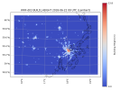 wrfrst_build_height_d03_lambert.png340.5 KB · Views: 3
 -
namelist.input7.8 KB · Views: 2
-
namelist.wps1.5 KB · Views: 1
-
geo_em4.5d01.zip5.4 MB · Views: 1
-
geo_em4.5d02.zip4.8 MB · Views: 0
-
geo_em4.5d03.zip4.6 MB · Views: 0
-
geov4.4d01.zip5.4 MB · Views: 0
-
geov4.4d02.zip4.8 MB · Views: 0
-
geov4.4d03.zip4.6 MB · Views: 0