rpkamakura
New member
I am trying to run a quick (1 day) simulation with real data, including SST. I am just testing the set-up to prepare for longer (~1-3 week) simulations where I am specifically interested in understanding the influence of different SST scenarios, so I am running with sst_update on. [Edit for more context: I am also running it with urban data since it is covering the Houston/Galveston Bay area, not sure if relevant]
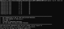
I managed to run WPS (geogrid, ungrib, and metgrid) successfully. However, when I try to run real.exe it terminates after ~30 seconds without any informative error codes. I have attached my rsl.error and rsl.out files along with the namelist.input file as well as a screenshot of the output in the terminal. I will detail more about the run set-up below.
========================================
name=SST
interp_option=wt_average_4pt
fill_missing=0.
interp_mask=mask(1)
masked=land
missing_value=-1e+30
flag_in_output=FLAG_SST
========================================
I am not sure where to even start debugging, would love any guidance y'all might have!
I managed to run WPS (geogrid, ungrib, and metgrid) successfully. However, when I try to run real.exe it terminates after ~30 seconds without any informative error codes. I have attached my rsl.error and rsl.out files along with the namelist.input file as well as a screenshot of the output in the terminal. I will detail more about the run set-up below.
- Running in windows powershell (have a windows machine)
- WRF compiled with dmpar GNU (gfortran/gcc) [option 34]
- WPS compiled dmpar with gfortran [option 3]
- I converted the netcdf file of the high-resolution SST to the intermediate file format
========================================
name=SST
interp_option=wt_average_4pt
fill_missing=0.
interp_mask=mask(1)
masked=land
missing_value=-1e+30
flag_in_output=FLAG_SST
========================================
I am not sure where to even start debugging, would love any guidance y'all might have!
Attachments
Last edited: