Scheduled Downtime
On Friday 21 April 2023 @ 5pm MT, this website will be down for maintenance and expected to return online the morning of 24 April 2023 at the latest

geogrid.exe stops without error with my own binary file

JSY

New member
Hi, all
I'm trying to replace the MODIS land cover data with the high resolution data which has shape format.
I changed this file with QGIS and made binary file with write_geogrid.c code which is in the WPS/geogrid/src directory.
I moved this binary file into the GEOG directory to run geogrid. I also wrote index and changed GEOGRID.TBL.
But I cannot run geogrid.exe successfully. There's no specific error message.

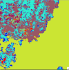
Here is my ascii file which is converted to binary file, index, GEOGRID.TBL, namelist.wps, and geogrid.log

If you have any idea, please let me know.
Thank you.

Best regards,
Soyoung
 

Attachments

  • ascii6.txt
    2.3 MB · Views: 2
  • index.txt
    358 bytes · Views: 3
  • GEOGRID.txt
    19.3 KB · Views: 4
  • namelist.wps
    1.3 KB · Views: 2
  • geogrid.log
    3.4 KB · Views: 3
Hi Soyoung,
When you convert the ascii file to a binary file, are you using the correct naming convention (see this section of the WPS chapter in the WRF Users' Guide)? If so, can you also share that binary file so I can test this on my end? Thanks!
 
Thank you for reply. Yes, I think I am using the correct naming convention. Here is my index and binary file. I slightly modified the index file but it still doesn't work.
 

Attachments

  • binary.zip
    926 bytes · Views: 4
Thanks for sending that. Unfortunately I'm not able to recreate your issue because geogrid ran quickly to completion for me. Since we use a shared WPS_GEOG folder here, I created an EGIS folder in my local directory, and then in the GEOGRID.TBL, I modified this line

Code:
rel_path = EGIS:EGIS/

to

Code:
abs_path = EGIS:/my-local-path/EGIS/

and I put the 00001-00751.00001-00751 and index file inside the local EGIS directory. The only thing I modified in your namelist was the path to our shared WPS_GEOG directory.

Are you running geogrid serially (i.e., just issuing 'geogrid.exe' in the command line), or in parallel, using an mpi command? If you are running in parallel, try recompiling the code so that you can run it serially and see if that makes a difference. Other than that, the only other recommendation I have is to try recompiling WPS, altogether, to see if that helps. I know it sounds silly, but occasionally this fixes issues.
 
I modyfied the line in the GEOGRID.TBL but still it stops. I compiled WPS again and again, but there is an error message that I can't understand.
Code:
Parsed 28 entries in GEOGRID.TBL
Processing domain 1 of 1
PGFIO-F-231/formatted read/internal file/error on data conversion.
 In source file source_data_module.f90, at line number 1089

I found the line number 1089 in source file source_data_module.f90 but it looks like I have to change nothing.
Code:
1087                   else if (index('category_min',trim(buffer(1:i-1))) /= 0) then
1088                      is_category_min(idx) = .true.
1089                      read(buffer(i+1:eos-1),'(i10)') source_category_min(idx)
I'm running this serially.
Thank you for your help.
 
Last edited:
You shouldn't need to modify your GEOGRID.TBL. I only had to do that because of the way my directories are structured. The new error you're getting could be due to changing the GEOGRID.TBL. Can you try the original GEOGRID.TBL you were using to see if you get a different error?
 
I still have the same error that I mentioned like
Code:
PGFIO-F-231/formatted read/internal file/error on data conversion.
 In source file source_data_module.f90, at line number 1089
I compiled WPS and WRF again but nothing changed.
The version I use is WRF-4.1.5 and WPS-4.1

If I run ./geogrid.exe without EGIS and just with default, it successfully runs.
Please let me know if you have any idea.
 
I tried again with WPSV4.1 (I was previously using WPSV4.5), but geogrid still runs without any issues. However, I looked closer at the geo_em* output files and they are not right. I'm attaching two screenshots, showing you what the default LU_INDEX looks like, and then what it looks like with your data. Many other fields also look wrong. I also tried to plot your tile, using the Python script posted by mgduda in this post, and it says the tile does not have the expected number of elements. So either something went wrong when you processed these data originally, or something is inaccurate in the index file. You may need to go back and see if you can figure out what is going wrong.
 

Attachments

  • LU_INDEX_default_modis.png
    LU_INDEX_default_modis.png
    79.5 KB · Views: 4
  • LU_INDEX_EGIS.png
    LU_INDEX_EGIS.png
    14 KB · Views: 4
Top