Hello everyone,
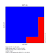
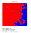
I encountered some issues after adding SST data into my WRF simulation. The SST data I used is from the ERA5 reanalysis dataset with a resolution of 27 km. I am using WRF version 4.3.2. The two images below show the visualization of SST and LANDMASK from the wrfout file. As you can see, the SST data still maintains the same resolution as the input dataset. This causes a mismatch between the SST and the coastline, resulting in a coarse grid-like jagged error near the coast.I would like to ask: How can I make the SST data better align with the coastline during the simulation and avoid this jagged grid error? I have attached the visualizations of SST and LANDMASK, as well as my namelist.wps and namelist.input files for reference.
Thank you!